Friday, 4 August 2017

On the Road to Mount Rushmore

Leaving Durango, we took a slow and easy drive to Mount Rushmore in South Dakota, spread over several days and where we could, taking the less busy roads. First stop was to be Grand Junction and getting there would take us high up and through the Rockies, passing Silverton along the way. Here's the route for the first day.

We didn't stop at Silverton, but we did at Ouray, which likes to think of itself as a bit of Switzerland in the USA.


Mountain scenery heading from Silverton to Ouray
Looking down onto Ouray on the road from Durango & Silverton
The really good bit about driving a monster RV in the US is that you can stop and park wherever you like. And if you take up three parking spaces, then that's fine. The downside, though is that if you are on a meter, you have to pay for all the spaces. But on the other hand, they really like tourists around here, so you'd probably get away with it...

Numerous old buildings remain and add to the character

Main Street. It is rather hilly!
Leaving Ouray, the route varies from mountainous and forested to open plain and took us into Grand Junction where we found our campground for the night. Tonight it is going to be another KOA site. Some of these seem to get a bad press, but this one is great. It's next door to the State Fairground and close to a busy road, so it might be different at other times, but while we were there it was great with very friendly staff and a good plot for us to use overnight.


Heading away from Grand Junction, we travelled by Interstate to the small town of Rifle where we headed north and up into more mountains. Here's the route..

Our destination was Steamboat Springs, a ski resort and we were visiting in mid-summer. It wasn't on the original plan, which was for us to head to a State Park to the north for some chill out time. But we discovered that this entailed 60 miles or so on gravel roads, so a rapid replan took place before we left home. We were staying again at a KOA, but any hopes we had of this being like the previous night's stop were dashed. It is old, a little run down, cramped and things just don't work as they should. So can't recommend this one - but it is the only choice in town.

In its favour, though, it is on a free bus route into town, so off we went to explore. We are at one end of town and the main ski resort area is at the other. So we took the bus to "our" end of town and went for an explore. That didn't take long...
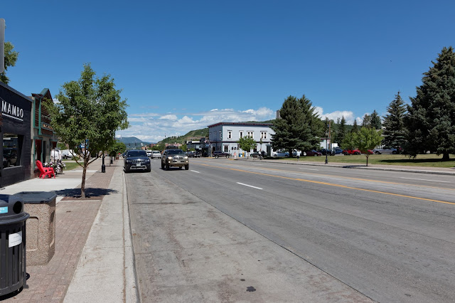
Downtown Steamboat Springs
A block back from the main drag, we find a river and go for a stroll:

And now, having exhausted the attractions of the town, we think that we'll head off to the ski resort and see what is there. Even if the answer is "nothing", we can take the lift up to the top of the hill and admire the scenery. What was there? Nothing! And the lift was closed for maintenance. Great...

OK, so back into town and find somewhere for lunch, which turned out to be a pub:

 
That was an improvement! After libations and refreshments, we head back, taking in the town museum along the way. There was a large display on Butch Cassidy, who had "connections" with the area.
Ann relaxing on the porch of the museum building
And then off on the next bit of the journey, following this route. It was a long journey, climbing even higher into the mountains until we reached the Wild West town of Laramie. Here we took a break at the only tourist place we could find, which happened to be the local prison. Actually, it was interesting and worth the stop. It's claim to fame? It's most famous inmate was one Butch Cassidy

Mountain scenery along the road to Laramie. Notice the snow - and this was late June!

Wyoming State Prison at Laramie

One of the cellblocks at Laramie. Despite popular opinion, there are modern prisons in the UK that are not much different to this

And so eventually, we arrived at the KOA in Douglas, Wyoming, our stop for the night. This one was quite OK. Just a short drive now towards Mount Rushmore tomorrow. Here's the route. We found ourselves at last on decent roads! Wyoming and South Dakota have proper roads with smooth surfaces!! A stop at Walmart in Rapid City for victuals and we were set up for the next 4 nights. And the car we had rented was waiting for us. A *bit* smaller than our RV, but it will do very nicely...


Next time, we'll go to Mount Rushmore, then to Deadwood and then in search of some wildlife.

If you have enjoyed looking at these pictures and others in this blog, they are available in higher quality and resolution at my gallery http://kevinwarrington.zenfolio.com/ where you can purchase prints, artwork and gift items.

Thursday, 3 August 2017

The Durango Kids

It sounds like it should be a cowboy town, but Durango's real claim to fame is being a railway town on the Denver and Santa Fe system and home to what is probably the most famous narrow gauge steam railway in the world, mostly because it has been on the television so many times. It was on our route (conveniently) and a ride on the line has been on my "bucket list" for ever.

Conveniently, the line ran through our campground and we were given a site in the first row, so we were as close to the line as we could possibly get.

The view from our site

We stayed for three nights, which gave us two whole days in town. One was dedicated to the train ride to Silverton, so on our first full day, we took the local bus the 5 miles into town. It cost us just $1 each return.

Downtown Durango
The railway depot has a museum located in the roundhouse, built to replace the original building that burnt down. It seems most Western towns have burned down more than once and Durango is no exception!

Our closest encounter with a bear. This one was stuffed.
And then the trip to Silverton the following day. On our day of travel, there were three return services to Silverton; one of which was run in two parts, so in total there were to be four trains running each way. We were on the second departure, so we arrived early to watch the action

Durango grinds to a halt as the trains leave. There are many ungated crossings, so the bells ring and the whistle is sounded continuously all the way through the town.

It's a holiday, so with all thoughts of cost cast to the wind, we have paid to travel First Class and have the end seats in the final carriage with easy access to the rear platform to hang out for pictures.

Our seats in the First Class Parlor Car. Ann has adopted her characteristic on holiday "film star" look with the large sunglasses

The line climbs all the way, following the course of the Animas river most of the way. To begin with, the climb is quite gentle, through trees.


Before long, we have arrived at what is called the "High Line". This is a shelf the width of the train that has been blasted into a 1000 feet high cliff. The cliff extends 600 feet above and therefore the drop into the rapids below is 400 feet. If you don't like heights, do not look down. At this point, I'm hanging off the rear platform to get the best view.

Curving around the wide part of the highline. I'm at the back of the train taking pictures.

Looking down into the canyon and the rocks 400 feet below. I'm at the back of the train, now hanging over the canyon taking pictures.
The line crosses back and forth over the river and the question is always which side is the best to sit? It doesn't make a huge difference as the train is turned around for the return journey, but it did seem to be working harder on the journey to Silverton, so my suggestion would be that a seat on the right side is probably better - and that is what we did.

Approaching Silverton, the scenery becomes pure mountain and trees.


The old depot at Silverton is no longer used, so the train just pulls up in the street, rather like a tram!

With all the original mines now being worked out, Silverton is now a tourist town. We managed to choose probably the worst restaurant in town for lunch! It served pasties, which is about right as the pasty is an international miner's food. But not at all like the proper Cornish pasty, even though the same shape. I think the content was a mix of left overs and washing water. The beer was OK, though.  We had a stroll through Silverton. Or as we are out West, maybe that should be a "mosey"

The only paved street in town

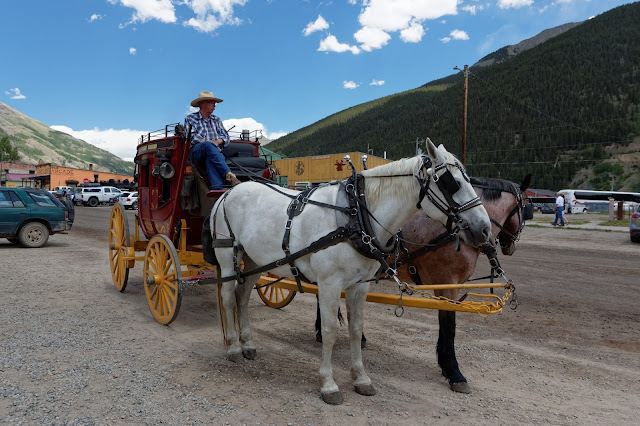
A ride around the town in the stagecoach was an option, but we chose to walk
Time to leave...  We are in the same seats on the way back, but as the train has been turned around, we are now on the opposite side, so the scenery is quite different.


We were intending on a meal out on our return, but the effect of lunch was still with us, so it was back to the RV and a simple salad. Good points: Durango is an interesting town; the train trip and wandering around Silverton. Bad bits; It is high in the mountains and hot, hot, hot! Hard to believe it gets cut off in the winter by the snow.

If you have enjoyed looking at these pictures and others in this blog, they are available in higher quality and resolution at my gallery http://kevinwarrington.zenfolio.com/ where you can purchase prints, artwork and gift items.

Saturday, 29 July 2017

Monument Valley

If Bryce Canyon should have been called "Ruby's", then Monument Valley should be "Goulding's". Originally, Mr & Mrs Goulding set up a Trading Post but with tough times in the 1930s, came up with the bright idea of using the area as a location for the rapidly growing film making industry, considering that it would be perfect for Westerns. Director John Ford clearly agreed and the rest, as they say, is history with the area being one of the most easily recognised vistas being familiar not only from just about every Western made from the 1930s onwards, but from modern films and many adverts.

We stayed on the Goulding complex, pitching ourselves in their RV park. There are a couple of other primitive parks, but this one has useful things like full hook ups and enough electricity to run the air-con.


The view from our plot

We're behind the tree with our patio on the "wrong" side. For some reason, this area of the park was filled up every day with little space between the units, while the rest of the site was only sparsely used
We arranged a tour through the Valley, led by a Navajo guide who took us with a group of about 8 in the back of the proper tour vehicle pickup truck. Many of the rock formations have been given names, but a little imagination is required to see why. Once you see the image, it becomes obvious!


John Ford Point, named for the film director who would ride out to here most days. It looks almost like a cigarette advert!


Starting point was a visit to a "hogan"- the traditional housing for the local Navajo. Despite what we think, they never lived in teepees; these were just for ceremonial use. Hogans are made from wood slotted together and then covered in mud.
We need a "volunteer" to demonstrate how an Indian's hair is tied up


First point of interest is "Three Sisters" It is supposed to look like three Catholic Nuns. I can see the image in the left one, but not the others...

This one looks like Alfred Hitchcock

And here is a Thunderbird (the mystical creature, not the car or rescue vehicle operated by International Rescue). You can see the "wings" and the effect of the feathers and with some imagination, the head, body and legs. I'm not sure what they were all smoking, but it must have been good stuff... 
Here's an example of a petroglyph. Obviously a good point for hunting as there were still many wild goats around.

Some of the rock formations close up were interesting. Here we have a cave with an open roof that gives the impression of being a natural bridge
After three nights, we were finding the heat a little intense and were really thankful to be moving on, heading back into Colorado and up into the mountains.  Leaving "Goulding's" took us along the road edging the Valley, famous for appearances in "Forrest Gump" and "Thelma and Louise", amongst others. In the distance in every parking space, we could see tourist busses parked up, spilling their loads of tourists onto the highway to take pictures.

The first landmark of any kind along the road is called "Mexican Hat". Another rock formation that looks like an inverted Sombrero balanced on another rock


Mexican Hat

You wonder how long it will remain balanced there! Our destination was Durango, following this route. The detour was to allow us to visit "Four Corners" - the only place in the US where four states meet. It is a freak of geography caused simply by lines being drawn on the map,but why not make a few bucks from it? As it is on Indian Reservation land, it is the local native Americans that profit from it and the monument is surrounded by a good craft market. 

There's a small fee to enter and of course, it is mandatory to take a picture on the point where the states meet:


A quick stop in Cortez for supplies and then to Durango. Why Durango? Probably the most famous narrow gauge steam railway in the US... More of that next time


Monday, 24 July 2017

Do you have a Reservation?

Leaving Bryce Canyon, we headed further into the wilderness of the "Four Corners" area, the majority of which is Navajo reservation territory and very little developed. Here's the route: Bryce to Page

We gained an hour on the journey; although Utah sits north of Arizona and both are in the Mountain Time Zone, Arizona does not keep daylight saving time, so in the summer, it is an hour ahead of the rest of the time zone, the same time as California and Nevada. except for a small part of the State that is covered by the Navajo Reservation and that *does* keep daylight saving time. Confused? You are not alone!  In the small town of Kanab, we have a choice of route 89 or 89A. Both are US highways and therefore well maintained, or at least as well maintained as any of the roads around these parts! I'd looked at various travel guides for suggestions and the best advice was that both are scenic, but 89A is usually less busy. They both form part of the direst Federal Highway network between Salt Lake City and Phoenix, two large cities that currently have no Interstate connection.

Along the way, we stopped for a "photo overlook" and got chatting to a Canadian couple who had travelled from Alberta. Lots of chat about the differences between the UK, Canada and the US - particularly how friendly the locals are. Having stopped, we thought we'd better take a picture:
a panorama looking over Dixie Forest and the "Grand Staircase" rock formations
There had been some controlled burning through the forested parts and along the way, what little traffic there had been turned off towards the North Rim of the Grand Canyon. We discovered a fail-proof method of finding a picnic area - you pull off the road into any form of track that looks level and with easy access to get back onto the highway, have lunch and sure enough, a mile or two along the road you'll come across a proper picnic area...

The forest ends as abruptly as it started and we were back in scrubby desert again. Marble Canyon sounded interesting (it wasn't) and the bridge across the Colorado looked good from Google Maps. There is a small visitor centre, but all the parking was taken, so we passed on by.

Our next stop was Horseshoe Bend, a landmark on the river where it makes a 180 degree bend in a deep canyon. It's signposted clearly with a large parking area and a trail up the hill to the viewpoint. Be warned...  Where the signs say to wear proper shoes (and absolutely not sandals) and carry plenty of water, they are not to be taken lightly. The sand is so hot that you will burn your toes and there is nowhere to get a drink or refill water bottles. There is a pavilion at the top of a hill in the right direction, so we head off thinking this is the viewpoint. It's about half a mile and about 400 feet up.

When we reach the pavilion, we discover that it isn't the viewpoint. That is now downhill, about half a mile further on. We've come this far... I should mention that the temperature is around 105 F approx 41 C and there is no shade!

When we get there, the view is worth the hike


Then there is the hike back to the parking. Like the Haynes car manuals say, it is simply a reverse of the outward procedure. You can just about see the half way pavilion in this next picture on top of the hill:


Time to find Wal-Mart to stock up on essentials and head to our RV Park. It's the only place in town and though it looks a little rough as you arrive, it is actually rather nice. Tomorrow, we are heading to Antelope Canyon.


Antelope Canyon

Page is a strange little town, originally a work camp for the building of the dam across the Colorado that created Lake Powell upstream of the Grand Canyon and the more famous Hoover Dam. It's the nearest town to Antelope Canyon and the reason we stayed there. Antelope Canyon is a "slot canyon", just wide enough for two people to pass - mostly - and between 20 and 40 feet deep. Being formed in soft rock, its claim to fame is in the light effects and patterns on the rocks. It is very popular for visits. Being in the Reservation, only accredited Navajo guides are able to provide tours. we splashed out on the more expensive and much longer "Photographer's Tour". words can't really describe this place, so the pictures will have to do:


Leaving Page, we headed to Monument Valley using this route. If you imagine the sort of scenery that you might see in a Western movie, that is exactly what you will find here. Miles and miles of nothing! Not a good place to break down...
First view of Monument Valley
In the next instalment, we'll look at Monument Valley. And we gave back the hour we'd gained.